Own race day
For race directors and resorts
Design, secure, and publish your course in one place.
Reuse last year's course, review it with your whole safety team on the same live map at the same time, and publish a runner-ready map to your race site with one line of embed. Built for events like UTMB.
In the Map Studio
The workflow, on screen
The capabilities you will lean on every week, shown at work in the editor.
Works with the tools you already use









Challenges we solve
Design, secure, and publish race courses in hours, not weeks.
Design to publish, one engine
Run operations and the participant map on one engine, not two. Course design, safety review, and the public map share a platform, with white-label embedding straight onto your race site.
Your whole race team, on one course, at once
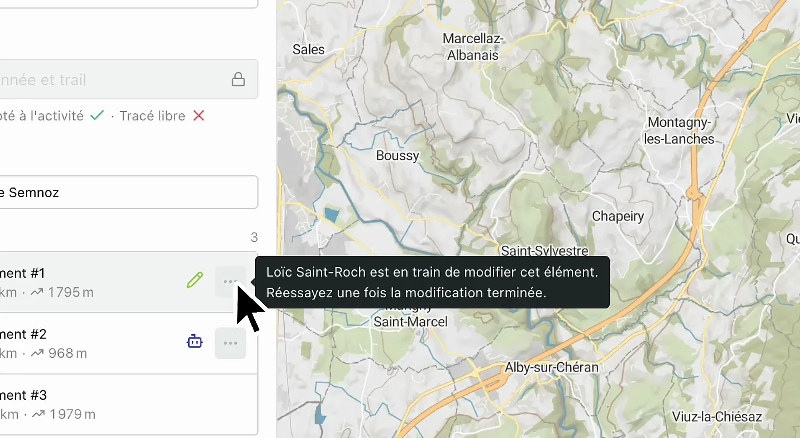
Course design stops being a relay of exported files. Race direction, safety leads, trail crews, and partners open the same itinerary together and edit it in real time, each cursor visible, every change landing live. Reroute the exposed traverse, move an aid station, and get sign-off in the same session instead of across a week of email.
Safety reviewed on the live map
Move safety off slide decks and onto the live map. Annotate risky sections, run on-foot rescue isochrones from every medical post, and sign off the course with your team, no email thread.
Reuse last year, change only what moved
Never redraw a course from scratch. Mirror a previous edition, swap aid stations, adapt to new permits, and recompute distances and splits in a few clicks.
Map Studio
Brief your crew and lock the course together
Athletes, safety teams, and event partners work the same live map. Annotate risky sections, compare variants, and sign off the final course without an email thread.
- Stakeholder sign-off in one session, no email thread
- On-foot rescue isochrones from every medical post
- Avalanche, weather, and surface overlays on the course
The toolkit
One workspace, nine sports, no lock-in
Structure the whole course in one place, switch sport and watch the routing retune, then take it out as a GPX or a branded flythrough.
Itinerary builder
Define segments, aid stations, checkpoints, waypoints, and route variants, all organized in a single workspace.
Nine outdoor activities
Trail, road, gravel, hiking, ski touring, and more. Routing, surface, and pace retune to the sport you pick.
GPX and KML, no lock-in
Import a file to recon a course, export any itinerary native to Garmin, Suunto, and Strava.
Export as video
Render a branded flythrough of the finished course for race briefings and social.
Course craft
The small moves that make a course real
A course is not one long line. Restructure segments, group them for the people reading the map, read the grade of the terrain, and publish only when it is ready.
Merge, split, insert
Combine two segments, cut one in two, or drop a new segment between two others, without redrawing the course.
Segments grouped into one leg
Group a run of segments so readers see a single clean leg on the map and the elevation profile.
SAC and bike difficulty grades
Read SAC hiking grades from T1 to T6 and mountain bike technical grades on every segment of the line.
Draft now, publish when ready
Keep editing in a private draft. Athletes, viewers, and embedded maps only ever see the published version.
Agents & API
The questions your team asks every day
Connect through an MCP server, Agent Skills, or GraphQL, and ask in plain language. Outdoor Intelligence answers.
Mirror last year's UTMB course but add the new aid station at km 87.
re-routed · splits recomputed at km 87
The agent loads last year's geometry, inserts the new aid station, and recomputes splits and distances around it.
Plot 30-minute on-foot rescue isochrones from each medical post.
≈9.1 km² per post · 2 gaps flagged
Reachability zones drawn for every medical post. Aid stations outside the 30-min zone flagged in red.
Reroute segment 4 to avoid the avalanche path between km 22 and 25.
bypass found · distance + ascent updated
Avalanche zone overlay enabled. Segment 4 rerouted onto the ridge bypass. Total distance and ascent recomputed.
Map Embedding
Your course, on your event site
Publish the official race map on your event and results pages. White-label it to your brand, and choose exactly what spectators see: elevation, aid stations, live weather.
Why outdoor teams switch to Mountaya

- Route you onto roads and highways
- Weather and terrain live in three other tabs
- Every route redrawn from scratch
- Reshaping a route means dragging every waypoint by hand
- Sharing progress means emailing GPX files back and forth
- Exporting to your watch means juggling apps
- Activity-aware routing that follows the trail under your feet
- Weather, terrain, and snow on the same map
- Set a brief, get matching routes in seconds
- An AI co-pilot edits the map from a prompt while you refine it
- Real-time collaboration: your whole team edits one map together
- One GPX that Garmin, Suunto, and Strava read natively
Use case
How Campus Coach embedded interactive maps for races and trainings on their website with Mountaya.

We connected Mountaya Embedding directly into our CMS, which lets us easily tailor the display to each type of race event (road running vs trail), adapting map data and styles to every use case. A solution that was quick to integrate and perfectly flexible for our use case at Campus Coach. The technical support was genuinely straightforward.
Orphée Besson

Pricing
Pricing built around how you map
| Monthly requests | Per request | Per 1,000 |
|---|---|---|
| Up to 20,000 | 0.0050€ | 5.00€ |
| 20,001 to 50,000 | 0.0025€ | 2.50€ |
| 50,001 to 100,000 | 0.0020€ | 2.00€ |
| 100,001 to 1,000,000 | 0.0015€ | 1.50€ |
| Over 1,000,000 | 0.0010€ | 1.00€ |
Tiered pricing: each tier of your monthly usage is billed at its own rate, then added together.
Prices in euros, VAT excluded. Usage is billed monthly, at the end of each billing period.
Built for trail, road, and ultra race directors, with Outdoor Tiles bundled in.
900€/year
1 × 900€/race · year
Ready to map your outdoors?
Start free in minutes, or talk to us about your team.
Frequently asked questions
Yes. Import GPX, KML, or paste coordinates, then refine the imported geometry, add segments, or apply weather and terrain constraints on top.
Yes. Map Studio ships with one-line white-label embedding. Elevation profiles, live weather, and your branding on your domain.
Yes. Map Studio is a real-time collaborative editor: race direction, safety leads, medical staff, and trail crews open the same course together, see each other's cursors, and watch every waypoint and overlay change land live. Annotate a risky traverse, run rescue isochrones, compare variants, and sign off together, without a single exported GPX going around by email.
Per race per year. For a full season or a multi-event series, we tailor a volume plan for your calendar. See the race pricing for details.